- Countries of the World
- Cities and provinces
- Complete Cooking Recipe Index
- Prophets' Stories
- Population of world countries by country
- List of surahs in the Holy Qur'an
- All Countries of the World
- Zip code in Jordan
- Traffic signs in Jordan
- List of world capitals
- International Calling Codes
- Al-Quran Recitations mp3
- List of currencies of the world
- Car Brand Logos and Names
- Jordanian Cuisine Guide
- Country codes names
- 6 Evergreen Content Topics
- World time zones by country
- Country flags of the world with images and names
- List of countries and dependencies by area
- List of countries and dependencies by population
What is GPS System? - Comprehensive 2024 Guide: From Satellites to Real-World Applications
How to Benefit from the Global Positioning System (GPS) for Free
How GPS Works
GPS satellites orbit the Earth twice daily in a very precise orbit and transmit signal information to Earth. GPS receivers take this information and use triangulation to calculate the user's exact location.
A GPS receiver must be locked onto signals from at least three satellites to calculate a 2D position (latitude and longitude) and track movement. With four or more satellites in view, the receiver can determine the user's 3D position (latitude, longitude, and altitude).
How Accurate is the Global Positioning System (GPS)?
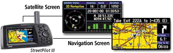
Today's GPS receivers are extremely accurate, thanks to their parallel multi-channel design. Garmin's 12 parallel channel receivers quickly lock onto satellites when first turned on and maintain strong locks.

Newer Garmin GPS receivers with WAAS (Wide Area Augmentation System) capability can improve accuracy to less than three meters on average. No additional equipment or fees are required to benefit from WAAS.
GPS Satellite System

Important Facts About GPS Satellites:
- The first GPS satellite was launched in 1978
- A full constellation of 24 satellites was achieved in 1994
- Each satellite is built to last about 10 years
- A GPS satellite weighs approximately 2,000 pounds
- Transmitter power is only 50 watts or less
What are GPS Signals?
GPS satellites transmit two low-power radio signals, designated L1 and L2. Civilian GPS uses the L1 frequency of 1575.42 MHz in the UHF band.
A GPS signal contains three different pieces of information:
- Pseudorandom Code: Simply an ID code that identifies the satellite
- Ephemeris Data: Information about the satellite's status, date, and time
- Almanac Data: The location of each satellite at any time throughout the day
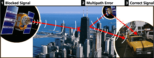
Sources of GPS Signal Errors
Factors that can degrade GPS signals and thus affect accuracy include:
- Ionospheric and Tropospheric Delays: Satellite signals slow down when passing through the atmosphere
- Signal Multipath: When GPS signals reflect off objects before reaching the receiver
- Receiver Clock Errors: The receiver's built-in clock is not as accurate as atomic clocks
- Orbital Errors: Inaccurate information about the satellite's position
- Number of Visible Satellites: More satellites result in greater accuracy
- Satellite Geometry: The relative position of satellites affects accuracy
- Intentional Signal Degradation: This system was discontinued in May 2000
What is GPS? | GPS Applications | GPS Glossary
Be the first to comment on this topic!
Leave a Comment