- بلدان العالم
- مدن ومحافظات
- فهرس وصفات الطبخ الكامل
- قصص الأنبياء
- سكان دول العالم حسب البلد
- قائمة بأسماء سور القرآن الكريم
- جميع دول العالم
- الرمز البريدي في الأردن
- شواخص المرور في الاردن
- قائمة عواصم العالم
- رموز الاتصال الدولي
- تلاوات القرآن الكريم mp3
- قائمة العملات في أنحاء العالم
- أسماء وشعارات ماركات السيارات
- المطبخ الأردني الشامل
- أسماء ورموز البلدان
- 6 فئات محتوى "لا تموت"
- قائمة المناطق الزمنية حسب البلد
- أعلام دول العالم مع الصور والأسماء
- قائمة الدول والتبعيات حسب المساحة
- قائمة الدول والتبعيات حسب عدد السكان
ما هو نظام GPS؟ - الدليل الشامل 2024: من الأقمار إلى التطبيقات
كيفية الاستفادة من نظام تحديد المواقع العالمي GPS مجاناً
كيف يعمل نظام GPS
تدور الأقمار الصناعية لنظام تحديد المواقع العالمي (GPS) حول الأرض مرتين يوميًا في مدار دقيق جدًا وتنقل معلومات الإشارة إلى الأرض. تأخذ أجهزة استقبال GPS هذه المعلومات وتستخدم التثليث لحساب الموقع الدقيق للمستخدم.
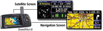
يجب أن يكون جهاز استقبال GPS مقفلاً على إشارة ثلاثة أقمار صناعية على الأقل لحساب الموقع ثنائي الأبعاد (خط العرض وخط الطول) وتتبع الحركة. من خلال رؤية أربعة أقمار صناعية أو أكثر، يمكن لجهاز الاستقبال تحديد موقع المستخدم ثلاثي الأبعاد (خط العرض وخط الطول والارتفاع).
ما مدى دقة نظام تحديد المواقع العالمي (GPS)؟
تتميز أجهزة استقبال GPS اليوم بأنها دقيقة للغاية، وذلك بفضل تصميمها المتوازي متعدد القنوات. تتميز أجهزة الاستقبال ذات القنوات المتوازية الـ 12 من Garmin بالقفل السريع للأقمار الصناعية عند تشغيلها لأول مرة وتحافظ على أقفال قوية.

يمكن لأجهزة استقبال GPS الأحدث من Garmin المزودة بقدرة WAAS (نظام تعزيز المنطقة الواسعة) تحسين الدقة إلى أقل من ثلاثة أمتار في المتوسط. ليست هناك حاجة إلى معدات أو رسوم إضافية للاستفادة من WAAS.
نظام تحديد المواقع عبر الأقمار الصناعية

حقائق مهمة عن أقمار GPS:
- تم إطلاق أول قمر صناعي لنظام تحديد المواقع العالمي (GPS) في عام 1978.
- تم تحقيق كوكبة كاملة من 24 قمرا صناعيا في عام 1994.
- تم بناء كل قمر صناعي ليدوم حوالي 10 سنوات.
- يزن القمر الصناعي لنظام تحديد المواقع العالمي (GPS) حوالي 2000 رطل.
- قوة الارسال 50 واط فقط أو أقل.
ما هي إشارات GPS؟
ترسل أقمار نظام تحديد المواقع العالمي (GPS) إشارتين راديويتين منخفضتي الطاقة، وهما L1 وL2. يستخدم نظام تحديد المواقع المدني تردد L1 البالغ 1575.42 ميجا هرتز في نطاق UHF.
تحتوي إشارة نظام تحديد المواقع العالمي (GPS) على ثلاث أجزاء مختلفة من المعلومات:
- الرمز العشوائي الزائف: هو مجرد معرف يحدد القمر الصناعي
- بيانات التقويم الفلكي: معلومات عن حالة القمر الصناعي والتاريخ والوقت
- بيانات التقويم: موقع كل قمر صناعي في أي وقت طوال اليوم
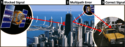
مصادر أخطاء إشارة GPS
تشمل العوامل التي يمكن أن تؤدي إلى انخفاض إشارة GPS وبالتالي التأثير على الدقة ما يلي:
- تأخيرات الأيونوسفير والتروبوسفير: تتباطأ إشارة القمر الصناعي أثناء مرورها عبر الغلاف الجوي
- إشارة متعددة المسارات: عندما تنعكس إشارة GPS عن الأجسام قبل أن تصل إلى جهاز الاستقبال
- أخطاء ساعة الاستقبال: الساعة المدمجة في جهاز الاستقبال ليست دقيقة مثل الساعات الذرية
- الأخطاء المدارية: معلومات غير دقيقة عن موقع القمر الصناعي
- عدد الأقمار الصناعية المرئية: كلما زاد عدد الأقمار الصناعية زادت الدقة
- هندسة القمر الصناعي: الموقع النسبي للأقمار الصناعية يؤثر على الدقة
- التدهور المتعمد للإشارة: تم إيقاف هذا النظام في مايو 2000
ما هو نظام تحديد المواقع؟ | تطبيقات نظام تحديد المواقع | معجم نظام تحديد المواقع
كن أول من يعلق على هذا الموضوع!
اترك تعليقاً