- Countries of the World
- Cities and provinces
- Complete Cooking Recipe Index
- Prophets' Stories
- List of surahs in the Holy Qur'an
- All Countries of the World
- Population of world countries by country
- Traffic signs in Jordan
- Zip code in Jordan
- List of world capitals
- International Calling Codes
- Al-Quran Recitations mp3
- List of currencies of the world
- Jordanian Cuisine Guide
- Car Brand Logos and Names
- Country codes names
- 6 Evergreen Content Topics
- World time zones by country
- Country flags of the world with images and names
- List of countries and dependencies by area
- List of countries and dependencies by population
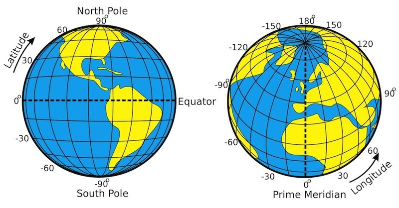
Geographic Coordinate System: Comprehensive Guide to Understanding Location Positioning
Geographic Coordinate System
نظام الإحداثيات الجغرافي
The fundamental system for locating positions on Earth's surface
Latitude180 parallel circles to the equator دوائر العرض |
Longitude360 lines meeting at the poles خطوط الطول |
Reference SystemWGS84 - Global System النظام المرجعي العالمي |
FundamentalsThe Geographic Coordinate System is a mathematical framework used to locate any position on Earth's surface through longitude and latitude lines. The system is based on two fundamental lines: the Equator (for circles) and the Prime Meridian (for lines), which intersect at the origin point in the Gulf of Guinea. Main ComponentsLatitude
Longitude
Global Reference SystemWGS84World Geodetic System 1984 - Global reference system used in GPS and modern systems Different countries used local reference systems until the 20th century (such as Ferro line, Paris line), and today the entire world uses the Prime Meridian as a unified system. Practical Applications
Practical ExampleDamascus City Location Latitude: 33° 30′ 35″ North |
Geographic Coordinate System "نظام الإحداثيات الجغرافي"
Technical Information
One Minute1.852 km (Nautical Mile) |
One DegreeApproximately 111.32 km |
International StandardDIN 13312 |
System AccuracyUp to 20 km variation |
Be the first to comment on this topic!
Leave a Comment