Al-Milaha fi Maqala
Your Path to Deeper Insight
- Countries of the World
- Cities and provinces
- Complete Cooking Recipe Index
- Prophets' Stories
- All Countries of the World
- List of surahs in the Holy Qur'an
- Population of world countries by country
- Zip code in Jordan
- Traffic signs in Jordan
- List of world capitals
- International Calling Codes
- Al-Quran Recitations mp3
- List of currencies of the world
- Car Brand Logos and Names
- Jordanian Cuisine Guide
- Country codes names
- 6 Evergreen Content Topics
- World time zones by country
- Country flags of the world with images and names
- List of countries and dependencies by area
- List of countries and dependencies by population
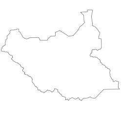
South Sudan
Official name: Republic of South Sudan
Also known as: southern Sudan
Capital of South Sudan: Juba
Area of South Sudan: 619,745 km² (239,285 mi²) (46th)
Population of South Sudan: 11,943,408 (81th) - (2024 est.)
Location: North East Africa
Languages of South Sudan: English (official), Arabic (includes Juba and Sudanese variants), ethnic languages include Dinka, Nuer, Bari, Zande, Shilluk
Religions of South Sudan: Sunni Muslim, Christian, other traditional beliefs
Currency: South Sudanese pound (SSP)
Calling code: (+211)
Organizations: United Nations, African Union, East African Community, and the Common Market for Eastern and Southern Africa, Greater Horn of Africa.
Border countries (6): Sudan (1,937 km/1,204 mi), Central African Republic (682 km/424 mi), Democratic Republic of the Congo (628 km/390 mi), Ethiopia (883 km/549 mi), Kenya (232 km/144 mi), Uganda (435 km/270 mi).
Coastline 0 km (landlocked)
South Sudan is divided into (10) states:
Central Equatoria, Eastern Equatoria, Jonglei, Lakes, Northern Bahr el Ghazal, Unity, Upper Nile, Warrap, Western Bahr el Ghazal, Western Equatoria; note - in 2015, the creation of (28) new states was announced and in 2017 four additional states; following the February 2020 peace agreement, the country was again reorganized into the (10) original states, plus 2 administrative areas, Pibor and Ruweng, and 1 special administrative status area, Abyei (which is disputed between South Sudan and Sudan); this latest administrative revision has not yet been vetted by the US Board on Geographic Names.
Natural resources: hydropower, fertile agricultural land, gold, diamonds, petroleum, hardwoods, limestone, iron ore, copper, chromium ore, zinc, tungsten, mica, silver.
note: South Sudan-Sudan boundary represents 1 January 1956 alignment; final alignment pending negotiations and demarcation; final sovereignty status of Abyei Area pending negotiations between South Sudan and Sudan.
— South Sudan, country located in northeastern Africa that was part of Sudan, its neighbor to the north, until 2011.
This page has been viewed
11554
times


Be the first to comment on this topic!
Leave a Comment