Al-Milaha fi Maqala
Your Path to Deeper Insight
- Countries of the World
- Cities and provinces
- Complete Cooking Recipe Index
- Prophets' Stories
- All Countries of the World
- List of surahs in the Holy Qur'an
- Population of world countries by country
- Zip code in Jordan
- Traffic signs in Jordan
- List of world capitals
- International Calling Codes
- Al-Quran Recitations mp3
- List of currencies of the world
- Car Brand Logos and Names
- Jordanian Cuisine Guide
- Country codes names
- 6 Evergreen Content Topics
- World time zones by country
- Country flags of the world with images and names
- List of countries and dependencies by area
- List of countries and dependencies by population
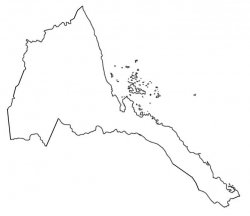
Eritrea
Official name: State of Eritrea
- Capital of Eritrea: Asmara
- Total Area: 117,600 km² (45,406 mi²) (Rank 100)
- Population: 3,535,603 (Rank 132) - (2024 estimate)
- Location: Eastern Africa, bordering the Red Sea, between Djibouti and Sudan
- Languages of Eritrea: Tigrinya (official), Arabic (official), English (official), Tigre, Kunama, Afar, other Cushitic languages
- Religions in Eritrea: Sunni Muslim 37%-52%, Eritrean Orthodox 47%-63%.
- Ethnic groups in Eritrea: Tigrinya 50%, Tigre 30%, Saho 4%, Afar 4%, Kunama 4%, Bilen 3%, Beja 2%, Nara 2%, Rashaida 1% (2021 estimate)
- Currency: Eritrean Nakfa (ERN)
- Time zone: UTC+3 (EAT)
- Calling code: (+291)
- Organizations: United Nations
- Border countries (3): Djibouti 125 km (78 mi), Ethiopia 1,033 km (642 mi), Sudan 682 km (424 mi)
- Coastline: 2,234 km (1,388 mi) total
- Maritime boundaries: Red Sea
Major Cities and Regions of Eritrea
Eritrea is divided into (6) regions (zobatat, singular - zoba)Anseba, Debub (South), Debubawi K'eyyih Bahri (Southern Red Sea), Gash-Barka, Ma'ikel (Central), Semienawi K'eyyih Bahri (Northern Red Sea).
These regions include major cities and towns of historical or economic importance:
1. Asmara
- Region: Ma'ikel (Central) region.
- Description: The capital and largest city of Eritrea. Located at an altitude of 2,325 meters above sea level, making it one of the highest capitals in Africa. Famous for its Italian Modernist architectural style from the colonial era, which is listed as a UNESCO World Heritage Site. Known as "Little Rome" due to its distinctive Italian architectural heritage.
2. Massawa
- Region: Semienawi K'eyyih Bahri (Northern Red Sea) region.
- Description: The main port of Eritrea on the Red Sea and the largest coastal city in the country. Characterized by its historical buildings reflecting Ottoman, Egyptian, and Italian influences. Massawa has been an important trading center for many centuries and is known as the "Pearl of the Red Sea".
3. Keren
- Region: Anseba region.
- Description: The second largest city in Eritrea, located in the northern highlands. Famous for its vibrant markets, especially the weekly livestock market. Features a moderate climate and is surrounded by scenic mountains, making it an important local tourist destination.
4. Assab
- Region: Debubawi K'eyyih Bahri (Southern Red Sea) region.
- Description: An important port in southern Eritrea on the Red Sea. It was of strategic importance as a military base during the colonial era and still plays a role in maritime trade. Located in an extremely hot desert area.
5. Mendefera
- Region: Debub (South) region.
- Description: A city located in southern Eritrea, previously known as "Addis Orgam". Famous for being the cultural and historical center of the Tigrinya people, containing many important archaeological and cultural sites.
6. Barentu
- Region: Gash-Barka region.
- Description: A city in western Eritrea and an important administrative center in the Gash-Barka region. Famous for being a center for the Nara people and plays a role in agriculture and trade in the western part of the country.
Natural resources: gold, potash, zinc, copper, salt, possibly petroleum and natural gas, fish.
Note: Eritrea has a strategic geopolitical position along the world's busiest shipping lanes; it retained the entire coastline of Ethiopia along the Red Sea upon de jure independence from Ethiopia on 24 May 1993. The border between Eritrea and Ethiopia is disputed.
Summary: Eritrea - Land of Cultural Diversity and Strategic Location
Eritrea is distinguished by its unique cultural diversity as a meeting point of African and Arab civilizations and influences, and its strategic location overlooking the Red Sea. The country is divided into 6 regions, with its most important cities being Asmara (the capital with Italian architectural heritage), Massawa (main port), and Keren (trading center). Eritrea is famous for its geographical diversity from green highlands to coastal shores.
This page has been viewed
11211
times


Be the first to comment on this topic!
Leave a Comment